Tocht Stappen Le Bonhomme - Tims Vosges J1 - Photo
 quinti6
quinti6

Gebruiker

© OpenStreetMap contributors
Lengte
Lengte
6,3 km
Max. hoogte
Max. hoogte
974 m
Positief hoogteverschil
350 m
Km-Effort
Km-Effort  
10,8 km
Min. hoogte
Min. hoogte
685 m
Negatief hoogteverschil
286 m
Boucle
Boucle
Neen
Datum van aanmaak :
2019-06-10 08:16:54.169
Laatste wijziging :
2019-06-10 08:25:42.376

(0 Bericht)

Stappen
Stappen
2h14
Moeilijkheid : Medium

Scan deze QR-code om de tocht te openen in de SityTrail-applicatie

Gratisgps-wandelapplicatie

Logo SityTrail SityTrail

IGN / Geografische instituten

SityTrail uit de App Store downloaden SityTrail uit Google Play downloaden

Logo SityTrail SityTrail World

De wereld gaat voor u open

SityTrail uit de App Store downloaden SityTrail uit Google Play downloaden SityTrail op Huawei AppGallery downloaden

Over ons

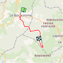
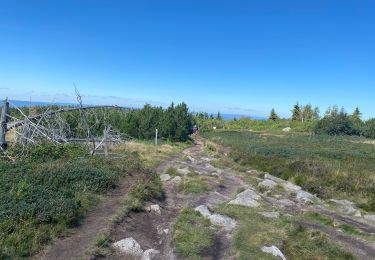
Tocht Stappen van 6,3 km beschikbaar op Grand Est, Haut-Rhin, Le Bonhomme. Deze tocht wordt voorgesteld door quinti6.

Beschrijving

Boucle de 4 jours de marche dans les Vosges (premier et dernier jour étant des demi-jours de  marche) au départ de Le Bonhomme. Première étape à l'Hotel Bouton d'Or à Lapoutroie. Le lendemain direction "Chez Chantal et Dany" à Soultzeren. Le troisième jour nous mènera aux Terrasses du Lac Blanc. Et enfin la matinée du quatrième jour nous ramènera sur Le Bonhomme.

Hoogteprofiel

Plaatsbepaling

Land:
France
Regio :
Grand Est
Departement/Provincie :
Haut-Rhin
Gemeente :
Le Bonhomme
Locatie:
Unknown
Vertrek:(UTM)
359757 ; 5337177 (32U) N.

Wandeltochten in de omgeving

Tocht Stappen Le Bonhomme - Tête des faux . - Photo
Stappen
heurtinpatrick

Stappen

Medium
(1)
Le Bonhomme, Grand Est, Haut-Rhin, France
11,9 km | 16,6 km-effort
3h 46min
Ja
Tocht Stappen Lapoutroie - 2012-06-16 Marche aux Alisiers Orbey - Photo
Stappen
GUIDE
holtzv

Stappen

Gemakkelijk
(2)
Lapoutroie, Grand Est, Haut-Rhin, France
11,1 km | 16,6 km-effort
2h 49min
Ja
Tocht Mountainbike Orbey - Lac Blanc  - Têtes des Faux - Photo
Mountainbike
tracegps

Mountainbike

Medium
(1)
Orbey, Grand Est, Haut-Rhin, France
15,3 km | 21 km-effort
1h 0min
Ja
Tocht Stappen Le Bonhomme - Le Bonhomme - Circuit du village - Photo
Stappen
GUIDE
Desrumaux

Stappen

Gemakkelijk
(1)
Le Bonhomme, Grand Est, Haut-Rhin, France
3 km | 5,3 km-effort
1h 30min
Ja
Tocht Stappen Sainte-Marie-aux-Mines - 2021-02-14 Marche Bagenelles Brezouard Fuste de Etoile - Photo
Stappen
GUIDE
holtzv

Stappen

Zeer moeilijk
Sainte-Marie-aux-Mines, Grand Est, Haut-Rhin, France
17,1 km | 27 km-effort
6h 6min
Ja
Tocht Stappen Lapoutroie - 2020-07-19 Marche Étang du Devin Col Calvaire Tête des Faux - Photo
Stappen
GUIDE
holtzv

Stappen

Heel gemakkelijk
Lapoutroie, Grand Est, Haut-Rhin, France
14,2 km | 22 km-effort
3h 27min
Ja
Tocht Stappen Fréland - CVL - Rando 25/03/2024 - Col de Chamont - Photo
Stappen
Hub6877

Stappen

Medium
Fréland, Grand Est, Haut-Rhin, France
6,6 km | 9,5 km-effort
2h 15min
Ja
Tocht Stappen Le Bonhomme - Lac blanc col du calvaire - Photo
Stappen
FOUCAULT

Stappen

Le Bonhomme, Grand Est, Haut-Rhin, France
5 km | 7,2 km-effort
2h 13min
Ja
Tocht Te voet Sainte-Marie-aux-Mines - Le Haïcot - Le Petit Brézouard - Le Haïcot - Photo
Te voet
patrickbeyrath

Te voet

Gemakkelijk
(2)
Sainte-Marie-aux-Mines, Grand Est, Haut-Rhin, France
7,1 km | 10,5 km-effort
2h 23min
Ja


Sluiten
Mijn abonnementen